

Punta de Teno Virgin Tenerife
The wildest, most secluded corner in Tenerife, in the north-west tip of the island, is the perfect idyll for a few days’ enjoyment of revitalising contact with nature – cycling excursions on the slopes of Teide, hiking through the humid laurel forests, canoeing under the huge sea cliffs… all this without having to leave this remote and amazing kind of “island within an island”. It even has its own microclimate, in an area which was practically inaccessible until just a few years ago. Here, far from the bustle of everyday life, any outing along the over one hundred kilometres of signposted trails reawakens one’s appetite for the fruit and recipes of a rich, fertile land which treats visitors to fresh scenery at every turn.
Mountain Biking – Pedalling On the Slopes of Mt Teide
The Corona Forestal Nature Park which, as its name suggests, forms a complete ring around the Teide National Park, offers four approved mountain-bike routes. The longest trail is the Ruta Norte (North Route), which covers 85 km on the main track, with another 52 km along side tracks.
Our first cyclotouristic proposal takes in one of its stretches but, in order to get the most out of the experience, the best option is to hire a local guide who will provide you with latest-generation bikes and escort you along the whole route, while pointing out details of the peculiarities of the delicate ecosystems in this rugged, vertical mountain terrain of the Teno massif. He will pick you up at your hotel in a flashy van, driving you up to an altitude of 1,600 metres on the slopes of Mt Teide, so that most of the trail will be downhill.
Forests and Volcanoes
In the vicinity of Montaña del Cascajo – a volcano, needless to say – the scenery is absolutely breathtaking. Hieratic fields of red lava are juxtaposed with lush forests of Canary Island pine, their rough bark bearing tell-tale signs of having suffered the scourges of the odd forest fire. According to Iván Méndez, our guide, these pines are “natural survivors”, as this indigenous variety is fire-resistant.
With hardly any effort we enter the Chinyero Special Nature Reserve, a volcano of black earth which last erupted in 1909, located alongside another volcano which two centuries earlier swept away most of the port of Garachico, a small town situated 8 kilometres away.
A bit further down we enter the underworld of Macaronesic laurisilva, shrouded in a dense cloak of mist. We pedal through a gloomy, watery universe characterised by vegetation similar to what covered much of the earth 65 million years ago, which nowadays is found in but very few isolated spots.
After several forested kilometres we return to civilisation to refuel in a tavern with views where they serve up roast cheese with red mojo and palm syrup, codfish with sweet potato and roast goat meat… delicious!
We reach our hotel with a sweet tang on the palate and not at all tired. We have cycled just 42 km, with a drop of 1,800 metres and a climb of only 200 metres, yet feeling as if we had just discovered a piece of nature brimming with allure. Never before had we seen, felt and breathed in so many different landscapes and microclimates in so few kilometres.
Walking Expeditions – Endless Trails
Thanks to a vast network of signposted footpaths, the Teno Rural Park offers myriad itineraries of all ratings.
If you stay at Buenavista, for instance, there is a nearby access route to the spectacular, heady Bujamé Gorge, namely the PR-TF 58 Camino del Risco, which rises along an old path towards the green meadows of Teno Alto and the hamlet of Los Bailaderos, where you can taste one of the best craft cream cheeses in all of the Canary Islands. The route leads between Roque de Marrubio and Roque de la Cruz, and past the remains of an ancienttagoror,a meeting place for community leaders in the period of the Guanches. Oddly enough, this steep trail is known locally as “the descent of the dead” as, in bygone times and up until the 1970s, it was used to carry the deceased down to Buenavista from Teno Alto, where there is no cemetery. Another tell-tale sign is the Cueva de los Ataúdes (Cave of the Coffins), where you can still see two humble communal caskets – one for adults and another for children – once used for the arduous procession.
Owing to the rugged terrain of the Teno massif, virtually all routes are interconnected, so you can combine different stretches of them to create a personalised itinerary, depending on the time you have available or how far you care to hike. For instance, once in Los Bailaderos, you can continue eastwards along the PR-TF 57 Callejón de Teno as far as Cuevas del Palmar, or else westwards along the PR-TF 51 up to the Punta de Teno lighthouse. It is here, on the westernmost edge of the island, that you can witness an unforgettable sunset, with the cliffs known as Los Gigantes basking in the golden sun.
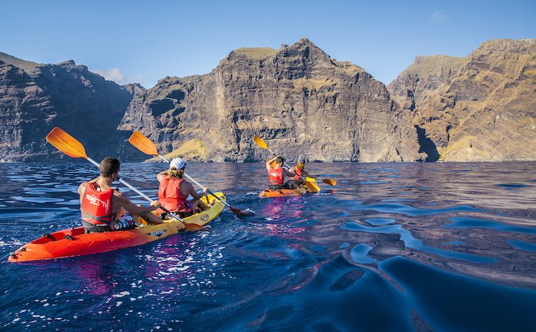
Canoeing Among Giants
In the time of the Guanches, these 600-metre-high basalt rock faces were known ominously as the “Muralla del Infierno” (Wall of Hell). Today they are called the “Acantilados de Los Gigantes” (Cliffs of the Giants) and the area is preserved as a veritable sanctuary on account of its inaccessibility. It is also the perfect spot for spending the day kayaking, as this stretch of water is permanently sheltered from the prevailing trade winds by the cliff faces, which provide a natural barrier, so that the sea is always calm.
The group outing starts in the Los Gigantes marina. It lasts for two hours and is guided by instructors, who comment on the peculiarities of this amazing spot. The excursion is suitable for people of all ages and no prior experience is required. What’s more, the party is escorted by a tracking boat which is always on hand to provide assistance in the event of any mishap. The kayaks are single- and two-seater beginner canoes which are totally stable and sit-on-top. Details and bookings: Teno Activo.
Trekking, Kayaking & Snorkeling in Crystal-Clear Water
El Eco bay is the ideal spot for swimming and exploring the seabed by skin diving in the crystal-clear water. At the foot of the cliffs, the maximum depth is just 30 metres. The same canoe or kayak excursion can start at Masca beach after walking the 5 kilometres down the gulley of the same name, then paddling back on the return journey as far as Los Gigantes after having visited Barranco Seco bay.
Whale Spotting
Dolphins and even whales can be spotted off the Los Gigantes coast, but in deeper waters. After the kayak outing, the best thing is to board a 36-seater boat which leaves from the same marina. The ride lasts two hours and, on the return trip, the boat weighs anchor for 15 minutes in Masca bay, allowing guests to have their last swim at the foot of the cliffs.
A Chill-out Hotel
The Melià Hacienda del Conde Resort Hotel is also located in this secluded enclave in the north-west of Tenerife. Affording splendid views over the ocean, it is the perfect base camp for spending an active and at once relaxing holiday in the Teno area. Their spacious rooms, swimming pools, spa, refined culinary offerings and adult-only status make this a favourite destination among visitors seeking peace and quiet.
Book your Vueling to Tenerife and venture out across the Teno volcanic massif.
Text by Sergio Fernández Tolosa of Con un par de ruedas
Photos by Sergio Fernández Tolosa and Teno Activo
more info

The route by the coastline of Wales
Green pastures and sharp cliffs are the regular landscape of Wales, a land full of myths and legends. At Snowdonia, northeast of Wales, it is said that King Arthur was born. Here you can find the tallest mountain in England and Wales, and the highest lake in Wales. It is located exactly at Snowdon – which refers to ‘snowy hill’ in old English – is the highest point of the park, which is named after it.
The best way to discover Wales is follow the coastline path, the longest in the world. To fully enjoy this wonderful natural environment, a 1.350 kilometers long path was inaugurate in May, 2012, Wales Coastal Path, which follows stunning landscapes.
It’s easy to get to the Welsh coastline. You should take into account that everybody around here doesn’t live further than one hour away to the beach. This is one of the most recommended destinations to nature lovers, as it goes by 11 natural parks and many other natural reserves, this route is accessible to hikers and parts of it are also accessible by bike, trolleys or people with reduced mobility.
Wales Coastal Path right from Chepstow (South Wales) to the mouth of river Dee, in the north, that is by the border between Wales and the Cheshire Country, in England. The route follows all the Welsh coastline in a path that will take you to the Gower peninsula – with sandy beaches by the area of Pembrokeshire-, the strait of Menai in the isle of Anglesey – that links to the land by an iron suspension bridge -, the seafront in Cardiff bay, the cliffs in Porthcawl or the Brecon Beacons National Park.
Along the way, you can enjoy rich and varied wildness species. The cliffs, bays and sandy beaches are great viewpoints to sight sea birds like guillemots, puffins, razorbills, gulls, glaucous and shearwaters. The popular Cardigan Bay is famous for the dolphins, gray whales and porpoises that visit the shore often to play with the waves.
Picture from Wales Coastal Path by Hogyn Lleol | Strumble Head by Hogyn Lleol | Pembroke by JKMMX
A place well worth discovering! Check out our flights here.
more info
Catalonia in 7 Coastal Routes
In the following we reveal seven routes in which culture, gastronomy, enotourism, sport and adventure come together to transform your visit to the Catalonian seaboard into an unforgettable experience.
Route 1 - From Sant Carles de la Ràpita to L’Ametlla de Mar (98 km)
Our point of departure is tinged with the marine flavour of oysters and mussels, which you can taste at La Caseta del Parrillo farm, part of the Ruta de las Bateas (Route of the Rafts), which involves a boat ride across the Alfacs bay in Sant Carles de la Ràpita. At Amposta, be sure to sign up for a tour of the Ebro Delta Nature Park with MónNatura Delta del Ebro. You can visit their interpretation centre, the salt marshes, the hides for observing estuary birdlife, as well as ride in the traditional punts. The finishing touch is supplied in L’Ametlla de Mar by the team at Tuna Tour, who will take you diving among red tuna, which you will also be able to taste at the end of the excursion.
Route 2 – From Tarragona to Gratallops (73 km)
Tarragona is the first stop on this second route, which includes a tour of the city guided by Icono Serveis, while Tarragona Experience goes a step further by taking you into their Roman kitchen workshop, Domus Apicius. After this heady dose of culture, it’s time to head for the Port Aventura amusement park, where thrills and excitement are guaranteed. How about a day’s fishing in a genuine fishing boat? The experience is yours at Pesca Turismo Cambrils, so make sure you don’t miss out on it! A stopover at Reus is the perfect excuse for visiting the Gaudí Centre, where you can follow the first few steps of one of the most outstanding and unique architects in this land. The itinerary ends in the Priorat region and their magnificent DO wine, which you can taste in such wineries as Clos de l’Obac, located in Gratallops.
Route 3 – From the Prades Mountains to Vilanova i la Geltrú (112 km)
Awaiting you in the Prades Mountains are villages like Farena, Alcover and Capafonts. You can also join some of the activities offered by Brogit Guiatges, including dramatised excursions, homemade cheese and honey tastings or walking with a shepherd. When you feel like a break, we recommend heading for one of the three monumental complexes making up the so-called “Ruta del Cister” (Cistercian Route), notably the Monastery of Poblet, where you can also stay the night. Wine lovers can take the opportunity to visit Pacs del Penedès and indulge in an enotouristic experience at the Torres Winery. We wind up this third itinerary at the town of Vilanova i la Geltrú, where you can observe a splendid sunset from a yacht. What more could you ask for?
Route 4 - From Sitges to Sant Sadurní d’Anoia (74 km)
In such an inspiring place as Sitges, one good option is to rely on AGIS to take you on a stroll through artists’ workshops. And, if you’re hankering for something racy, why not drop in on Casa Bacardí and learn how to make cocktails? The town of Santa Coloma de Cervelló is a must for devotees of Gaudian architecture, as there you can visit the Güell Colony and Gaudí’s Crypt. And, needless to say, this trip also includes a jaunt through the Penedès DO region where you can stop off at an organic wine cellar like Albet i Noya, or proceed to Sant Sadurní d’Anoia, home to the main cava wineries such as Codorníu.
Route 5 - From Montserrat to Caldes de Montbui (61 km)
One site you simply cannot afford to miss is Montserrat, a major symbol of Catalonia. There you can visit the monastery and the art museum, as well as hike through the amazing nature park. After this immersion in raw nature, you could head for Terrassa, which boasts a number of first-rate museums, notably the Museu de la Ciència i de la Tècnica de Catalunya, (Science and Technology Museum of Catalonia) Museu Tèxtil (Textile Museum) and Parc Audiovisual de Catalunya (Audiovisual Park of Catalonia). This itinerary winds down in “relaxation mode” at the Termes Victòria spa hotel, or the Broquetas Spa, both located in Caldes de Montbui.
Route 6 - From Montmeló to Palamós (155 km)
Are you a speed freak? Then the Circuit de Barcelona-Catalunya, located in Montmeló, is the place for you, where you can get to drive your dream car. And, if you have any energy to spare for more excitement, at Globus Voltor, in the town of Cardedeu, you can sign up for a hot-air balloon ride, or visit the Can Vila horse-riding school in Sant Esteve de Palautordera and explore the Montseny Nature Park on horseback. This route comes to a close in Sant Feliu de Guíxols, where a walk along the coastal footpath comes highly recommended, and Palamós, where you can take part in a seafood cookery workshop in the Espacio del Pescado.
Route 7 - From L’Estartit to Girona (149 km)
Our final route starts with a diving excursion led by the Aquàtica crew in the waters around the Medes Isles off the coast of L’Estartit, while the wetlands of the Empordà region are ideal for ecokayaking with the SK Kayak team. On the outskirts of the nearby village of Sant Martí d’Empúries you should make a point of visiting the Greek and Roman ruins, and a heady dose of culture awaits you in the monastery of Sant Pere de Rodes – dramatised visit included – the Dalí Theatre-Museum in Figueres, the Salvador Dalí House-Museum in Portlligat and the historic centre of Girona, which you can tour on a segway. The final flourish on this route is provided by the Empordà DO wines – you are urged to visit Empordàlia, located in the town of Vilajuïga, where you can taste wines, oil and the region’s typical dishes.
Text by the Agencia Catalana de Turismo
more info
Tuttomondo. Keith Haring’s last mural
It takes 180 square meters of the south wall of the Chiesa di Sant’Antonio Abate-the convent of the Friar Servants of Mary of the Church of San Antonio in Pisa. The art of Keith Haring, the renowned artist from New York, left the imprint in this pisan wall with a work that wants to give out a message of peace and citizen participation.
Tuttomondo is the only mural painting of the artist thought to be a permanent work, unlike his early works he executed quickly with white chalk on the Subway’s commercials. Haring was identified from the beginning with the Street Art, avant-garde art of the 80s that rebelled against the traditional system of exhibition galleries. So was born a way of counterculture related to graffiti and hip hop . His art seeks graphic simplicity that can be understood by everyone at first sight; uses images as graphic symbols.
The large mural was created in 1989, a year before he died, and took a week to be finished. Tuttomondo thereby became the last public work of Keith Haring. Everything came after a casual meeting in New York with a student from Pisa who proposed the idea. Thus the idea of Tuttomondo was born, a word that sums up the idea that the artist had about interaction with his audience, and in it 30 figures are represented to symbolize peace and harmony in the world . Each figure has a role within its gear, in this way men with dolphin represent man’s relationship with nature, the figures “human scissors” are a symbol of solidarity to defeat the snake symbolizing evil-or the woman with the baby represents motherhood.
Colours are also very important, and that was his election, Haring chose the tones of Pisa’s buildings, to keep harmony with the environment.
Image: Cutiekatie
A place well worth discovering! Check out our flights here.
more info