


The Palio di Siena
Situated some 75 kilometres south of Florence, Siena is a must-visit spot on any route through Tuscany. The architectural beauty of its historic centre, designated a World Heritage Site by UNESCO in 1995, is one of its major draws. A former marketplace, the Piazza del Campo –popularly known as Il Campo – is the undisputed centrepiece of the city’s social life and the ideal point of departure for sightseeing in Siena.
The square was paved in 1327 and divided into nine sections, one for each of the Noveschi – the nine oligarchs that ruled the city. It still transports the visitor to medieval times, due in part to the buildings around its perimeter, notably the Palazzo Pubblico and Torre del Mangia. The former, also known as the Palazzo Comunale, was built in the early 14th century. Located on the south side of the square, it houses the Museo Civico. The campanile on this palace is called the Torre del Mangia. A veritable icon of the city, its height of 102 metres affords the best panoramic views of Siena. At the top of the square is the Fonte Gaia, built to facilitate the channelling of water to the city centre. The fountain now on the site is a replica of the original, sculpted by Jacopo della Quercia, while the original is on view in the museum at Santa Maria della Scala.
A Medieval Tradition Which Never Ages
This square is actually the centre stage of one of the defining moments in the life of this beautiful Tuscan city – the celebration of the Palio di Siena. Every year the festivity attracts both locals and hordes of tourists, eager to relive a tradition which never seems to have aged. The focal point of this famous race is the Piazza del Campo. Once it is adorned with all the celebratory trappings, including flags and people dressed in period costumes, it is well nigh impossible for visitors to avoid feeling swept back to another time in history.
The key dates for the Palio, the origins of which go back to the 16th century, are2 July,with the running of the Palio di Provenzano (in honour of the Madonna of Provenzano), and16 August,when it is the turn of the Palio dell’Assunta (in honour of the Assumption of Mary). These are the two dates you need to jot down in your diary if you want to experience the most authentic moments in the life of Siena, or as dates to avoid, if you don’t fancy being swamped by crowds. On those two days, the Piazza del Campo is transformed into a thrilling, fast-paced horse race which actually only lasts for a mere two minutes. The participants consist of representatives of the sixteen contrade (parish districts), who vie for the honour of seizing the palio, a silk standard. By way of a warm-up in the days preceding the race, all sorts of competitions are held in a festive mood around the city, enhanced by the sight of colourful period costumes.
Visiting the City
Apart from the highly popular Piazza del Campo, Siena also has other interesting sights worth seeing on your visit to the city. One such landmark is the Duomo (Siena Cathedral), in Italian Gothic style, which houses works by Pisano, Donatello, Michelangelo and Bernini. One unusual feature is to be found in the floor, which has 56 panels depicting Biblical scenes, some of which can only be viewed in September and October as they are covered for conservation purposes. Also in the Piazza del Duomo is the Museo dell’Opera, with sculptures that were previously housed in the Cathedral, and the Santa Maria della Scala complex, a former hospital which now houses three museums – the National Archaeological Museum, the Siena Contemporary Art Centre and a Children's Art Museum.
Book your Vueling to Florence and head for Siena to coincide with the city’s festivities.
Text by Los Viajes de ISABELYLUIS
Image by Janus Kinase
more info

Underground. Belgrade goes under.
A city underground. This idea was developed by Emir Kusturica – filmmaker born in Bosnia, raised on Islam, later converted to Christianity and self-proclaimed Serbian – in the movie Underground (1995), which showed the eventful recent history of the former Yugoslavia in a tragicomic point of view, with the protagonists create their own world underground to protect their interests, forgetting about the events above the ground. This is some kind of Plato’s cave where they live isolated while about the Nazis invade the territory, later Tito regime during the Cold War and finally the Yugoslavian war.
Located strategically between western and eastern territories, at the confluence of the Sava and Danube rivers and by the Adriatic, Aegean and Black seas, probably is the European city that has been devastated and rebuilt again the most. Serbian capital has been occupied about 38 times in the past 300 years. Austrians, Serbians and Germans have created all kind of structures in the territory that Belgrade occupies.
The insides - a tangle of tunnels, shafts, caves and bunkers - have always been there, preserved during all these wars and also created because of them. Most of the historical center is on archaeological sites and hundreds of meters of tunnels were built for many reasons, during thousands of years.
Since 2012, some of these secrets can be revealed in Belgrade - even most of them still remain closed to the public – in a trip through subterranean routes. Total, there are about 140 structures certified officially nowadays, which are allowed to be visited.
But for now is almost impossible to know how many elements can be found underground. One person that knows this well is Zoran Nikolic, cowriter of Beograd ispod Beograda (‘Belgrade under Belgrade’) where he reveals the secrets that he now also shows as specialized guide around this area.
Under the library in Belgrade
By the start of Knez Mihailova street the City Library can be found, located in a building that used to be the most famous hotel in Belgrade. In the underground floors there is the Roman room, with well-conserved rests of an old fortress and a collection of Roman sculptures and graves. The room is used for lectures, music concerts and other cultural events.
Under the Belgrade fortress
Kalemegdan, the great Fortress of Belgrade, is one of the seven fortifications that stand by the Danube, along Serbia and at the confluence of the Sava and Danube rivers. Here is where, according to the legend, Attila was buried. The fortress along to the Kalemegdan Park, become the most relevant historic-cultural complex in Belgrade.
Under the ground there is Barutana cave, a former Austrian military warehouse now used as archaeological museum, including pieces from Singidunum, the antique Roman city that used to be where Belgrade is now, including sarcophagi, tombstones and altars.
Bellow the park there is also a fascinating bunker, from the last days of the Soviet Union. Josip Broz Tito, Yugoslavian head of state, wanted to built a bunker after World War II to protect Belgrade of a possible Russian invasion.
Near the fortress, artificial caves where used as food warehouses. Nowadays, restaurants and cellars are located here, where there is never a need for air-conditioned.
Under Tašmajdan park
One of the most significant parts of the route is under the centric park of Tasmajdan, right bellow the Serbian Parliament. Bellow asphalt and concrete layers there are caves built by the Romans that were used centuries after for many purposes: during the Great War they were a warehouse for bombs and during World War II they were used as hidden headquarters by the Germans.
Picture from wikimapia.org
A place well worth discovering! Check out our flights here.
more info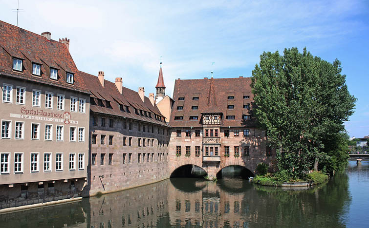
A tour through the history of Nuremberg
Nuremberg is one of those cities that allows you to organise an interesting tour through history without leaving town and no need for a time machine. A city that was bombed in 1945 and rebuilt shortly afterwards, its leading role throughout medieval, modern and contemporary history has left it with many historical attractions.
It was the capital of the German Empire between the 11th and 14th Centuries, a key centre during the German Renaissance and the main setting for the Thirty Years War (1632). Thanks to its importance during the imperial époque, Hitler made it the headquarters of the Nazi Party Congress and it was also in Nuremberg where various Nazi war criminals were tried and sentenced in Court Room 600 in the Palace of Justice .
Its history has left the city with many interesting monuments to be visited and Bavarian artists, such as Albercht Dürer have given Nuremberg an artistic heritage not to be missed. This tour offers a route through the city so you can find out all about in just one day.
Nuremberg Palace of Justice (Justizpalast)
Our tour of Nuremberg starts at this seat of judicial power, which today remains fully operational. It was here that the Nuremberg Trials took place that lasted almost one year and where the sentences handed out to some of the heads of the Nazi regime became a landmark in the history of international law.
The Court Room 600, the scene of these historic trials, is still used as a courtroom today and at the weekends, when it is not in use, offers guided tours. As an alternative, if you find the room closed, you can visit the “Memorium Nuremberg Trials” exhibition which can be found in the East Wing of the building.
German National Museum (Germanische Nationalmuseum)
Although this involves a large chunk of time and patience, as you have to queue up to get in, the visit to the German National Museum is well worth it as it is possible to see one of the greatest collections of modern German art to be found in Nuremberg, Germany and the world, all under one roof. Until 2 September, you can see “The Early Dürer”, a retrospective exhibition of the early works of German artist Albercht Dürer, a son of Nuremberg and the greatest exponent of the 16th Century German Renaissance.
On your way in or after your visit, opposite the museum entrance, is the Street of Human Rights , 29 commemorative columns that bear the 30 articles of the Universal Declaration of Human Rights . One curious thing, there are 29 columns and 30 articles (in 30 different languages) because the last column, in Spanish, had to be taken away because it was blocking the exit for the fire station. They said they’d replace it but…
Marriage Carousel (Ehekarussell)
Going into the city centre, at the foot of the Weißer Turm (White Tower), you will find a fountain that is not suitable for the recently married: the Marriage Carousel was sculpted in 1984 by Jürgen Weber. Its figures were inspired by the poem “Bittersweet Married Life” by Hans Sachs. The sculptures depict falling in love at the beginning, the routine of living together and ends up with… well, you’ll see for yourself.
Church of St. Lawrence (Lorenzkirche)
The Church of St. Lawrence, built in the 13th Century, is an example of the Hallenkirche (hall churches), the typical German Gothic churches, with three aisles of the same height. Most of it was rebuilt following the Second World War bombardments and among its curious details that catch your attention are the nets that protect the statues in the portico so that birds can’t make their nests there or the Braille information panel we came across at the entrance.
Hospital of the Holy Spirit (Heilig-Geist-Spital)
This is one of the most well-known postcards of the city of Nuremberg, photographed from the bridge opposite. On the banks of the River Pegnitz, the building was constructed between 1332 and 1339. Having fulfilled its duties as a hospital, it is currently a municipal home for the elderly.
Market Square (Hauptmarkt)
Another of the must-see spots you simply must not miss on any tour of Nuremberg, is dominated by the Church of Our Lady (Frauenkirche) built in 1358 by order of Emperor Charles IV. Its famous marketplace (particularly well-known for its Christmas Market but also offers a fresh produce and traditional food market during the rest of the year). Here you will find the Beautiful Fountain (Schöner Brunnen) that dates back to the 14th Century . The square is encircled by innumerable souvenir shops and the city tour bus stop is located right beside the historic fountain.
Bratwursthäusle
At this stage in the tour, we suggest a rest and something to fuel the stomach chance by sampling some traditional German food. Opposite the old Town Hall we found the Bratwursthäusle restaurant, where we could try the traditional German bratwurst accompanied by the equally emblematic pretzel. So sit down on the terrace and guten appetit!
Albercht Dürer’s House (Albercht Dürer Haus)
Fed and watered and after a short rest, you will be ready to walk to the highest area of the city. Before you leave the city walls, we recommend a visit to the house-museum that used to be the home of Albercht Dürer that includes in its exhibition, a chance to see the process carried out by Dürer when creating his famous etchings . Interestingly, in the square opposite the house, we discovered a curious sculpture reminiscent of one of the most well-known works by Dürer, the hare.
Imperial Castle of Nuremberg (Kaiserburg)
When you pass through the walls, you might be surprised to see gardens and orchards in the moat. The city hall rented the space out to the citizens of Nuremberg who use it as an urban vegetable patch or garden… Following the wall along for a few metres, we reach the Imperial Castle of Nuremberg from which point you can see the entire city (see the panoramic view at the start of this article). It was the residence of the German emperors from 1050 to 1571 and as well having preserved some of its original living quarters that are open to visitors, many other parts of the castle are still inhabited today.
Zeppelin Field (Zeppelinfeld)
To conclude this tour, we leave the city centre and to do this, if you haven’t done so already, we recommend you use the city’s public transport, specifically, the No. 36 bus route. You have to take this bus from the stop that is fairly near the castle then get off at the last stop on the line, that will leave you right opposite the Documentation Centre , inaugurated in 2000, the former Nazi Party Congress.
The original project for this building was to construct a half section of an amphitheatre in the style of the Roman Coliseum , with a conference auditorium in its centre. Now the building houses an interesting and modern information centre that can be visited, with a permanent exhibition documenting the history of the precinct and the ruthless abuse of power by the Nazi regime.
From there, you have to border the lake to reach the Zeppelinfeld itself: an enormous grandstand inspired by the Pergamon Altar from which Hitler directed the parades and Nazi Party congresses. Today, the area is very run-down and the city of Nuremberg only uses it for a >rock music festival held at the start of June (reminiscent of the 1970s) and a car race that takes place during the first week of July. Strange, isn’t it? Even so, you should pay a visit even if it is only to say “I’ve been there” before you go back into the city. Talking of the return, close to the Zeppelin Field there are two stops for the local train (S2) which will drop you off at Nuremberg’s central station.
Useful information
As regards transport, other than the cases we’ve mentioned, the rest of the tour can be done on foot. However, our advice is to pick up the Nürberg Cardfrom any of the city’s Tourist Offices that, for 21 €, gives you two-day access to all the museums and public transport. Children under 12 can get their card free of charge.
Another option to think about for getting around the city is NorisBike, a public bicycle hire service available to both residents of and visitors to Nuremberg. You can find more information about this service (in German) at aquí.
We’ll be there. If you want to come too, check out our flights here.
more info

The West Fjords the Remotest Most Unspoilt Iceland
Low light, wistful dusks, endless fjords, fishing villages accessible only by dirt track, thermal pools with views of the sea and, above all, tranquility – oceans of tranquility. All of this awaits travellers to Westfjords, Iceland’s loneliest, most unspoiled region. A few days spent exploring its secluded confines is the closest thing to what it must have been like until quite recently to travel around the now very popular Ring Road. We tell you how to reach this remote, captivating paradise and, once there, what to see.
1. Ísafjörður – the Old Fishing Capital
While it is the largest settlement in the Westfjords, Ísafjörður has just 2,600 inhabitants. However, in these latitudes, a census of this size is regarded as a veritable crowd of people.
The atmosphere is surprisingly lively in the quaint town centre, which features a considerable number of timber houses built in the 18th century. There are some good restaurants – fish and seafood are the local speciality – and pleasant cafés which, with the heating always up full blast, are a magnet for visitors seeking to take shelter from the invariably harsh weather outside. The Westfjords Maritime Museum is worth visiting as it is full of relics from the whaling era. It also provides valuable insights into the origins and the heyday of this isolated fishing port.
By land, sea and air: daily flights from Reykjavik have turned Ísafjörður into the quickest and most convenient port of entry to the Westfjords. It is also the point of departure for ships sailing to the Hornstrandir Nature Reserve.
2. Snæfellsnes – Journey to the Centre of the Earth
Those opting to instead make the journey to the far north overland from Reykjavik are advised to take a slight detour to explore the Snæfellsnes Peninsula. The scenic road runs around the perimeter of the whole peninsula and looming overhead is a spectacular volcano covered in glaciers which inspired Jules Verne for his novel, Journey to the Centre of the Earth.
Although the wind is usually rather gusty, the journey is rewarding as it is studded with breathtaking scenery, including lofty cliffs, rivers of lava and peach-coloured sandy beaches. One highly recommendable hike – wind permitting – is the coastal trail linking Arnarstapi to Hellnar. The 5 km route takes you past spectacular basalt formations, sea caves with blowholes weathered by the waves and natural rock arches.
3. Puffins on the Látrabjarg Cliffs
The Látrabjarg cliffs, marking the westernmost point in Europe – and probably one of the windiest, too – afford close-up sightings of the highly photogenic puffins, those flashy birds with colourful beaks that nest alongside other species on the impregnable crags, which rise to over 400 metres above the ocean.
Despite being endearing creatures, visitors should know that the locals once used to feed on puffin eggs and meat. In fact, puffin is still a select dish in some restaurants. The method used to catch these birds involves laying nets and abseiling down the cliff faces. Interestingly, the courage and skills of puffing hunters were put to good use when in 1947 a British vessel sank off these shores and all crew members were rescued and hauled one by one up the cliff faces.
Reaching Látrabjarg entails driving along one particular 50-kilometre stretch of dirt road (only on the outbound journey). Some 5 km before the lighthouse marking “Europe’s land’s end” is a rudimentary campsite suitable for camper vans or for pitching tents – there is a toilet and drinking water, but no showers or hot water.
The road takes you past Hnjótur, where there is a café and an interesting museum with a hotchpotch of items, including an aircraft from the United States Navy.
4. Thermal Pools at Reykjafjarðarlaug
Thermal pools are always a gift of nature but, in an environment like Westfjords, it becomes more of a genuine gift of the gods. One of the best warm pools – although not the only one – was built by a group of volunteers in 1975 opposite the Reykjafjörður fjord, just 50 metres off the dust road running between Bíldudalur and Hrafnseyri. The source of the spring lies a few metres upstream and wells up at 52°C, but the pool is kept at 38°C. Sadly, this is the way it was before, as in 2016 we found it closed. We hope it will reopen in 2017.
5. Dynjandi Waterfall
The Dynjandi waterfall (also known as Fjallfoss), which tumbles 100 metres in the shape of a beautiful staircase, is undoubtedly the most spectacular falls in Westfjords. It is reached by untarred mountain road and a simple camping area has been adapted for tents and camper vans. With its west-facing orientation, the best time of day to take your snaps is at dusk.
6. Seals and Jams at Litlibær
Some 70 km east of Ísafjörður in the direction of the Reykjanes thermal peninsula lives a colony of seals which is visible from the main road. To get an idea of how trusting the locals are, a farmer from the area leaves out some binoculars for anyone wishing to observe the seals in more detail, as well as a few jars of homemade jam and a piggy bank to pay the 6 euros for each jar they may want to buy.
7. Kayak Rides
In the next fjord, called Mjóifjörður (it’s easy to lose count of them), the newly paved Route 61 saves modern travellers from having to take the previous, roundabout way to the bottom of the estuary along the old 633 dirt road. Located in a remote spot is Heydalur, a country hotel with hot pools where they organise kayak outings that start at the site of the seal colony in the mouth of the fjord. Whales can also sometimes be spotted during the excursion, which lasts 5 hours.
8. Expedition to the Hornstrandir Nature Reserve
No one lives there, apart from the forest wardens, birds and Arctic foxes. This is the most isolated and unspoilt spot in Iceland and can only be reached by boat. Beyond the Hesteyri harbour – where you can sleep the night at the old doctor’s house, built in 1901 and with a capacity of 16 – there are no shops, restaurants or hotels. You will only find rudimentary camping grounds. Hence, the Hornstrandir Nature Reserve is the preserve of fauna and flora enthusiasts used to open-air living and the whims of Arctic weather. Some agencies organise guided hiking excursions lasting 4 or 5 days.
Text by Sergio Fernández Tolosa & Amelia Herrero Becker from Con un par de ruedas
Images by Con un par de ruedas
more info