

A tour through the history of Nuremberg
Nuremberg is one of those cities that allows you to organise an interesting tour through history without leaving town and no need for a time machine. A city that was bombed in 1945 and rebuilt shortly afterwards, its leading role throughout medieval, modern and contemporary history has left it with many historical attractions.
It was the capital of the German Empire between the 11th and 14th Centuries, a key centre during the German Renaissance and the main setting for the Thirty Years War (1632). Thanks to its importance during the imperial époque, Hitler made it the headquarters of the Nazi Party Congress and it was also in Nuremberg where various Nazi war criminals were tried and sentenced in Court Room 600 in the Palace of Justice .
Its history has left the city with many interesting monuments to be visited and Bavarian artists, such as Albercht Dürer have given Nuremberg an artistic heritage not to be missed. This tour offers a route through the city so you can find out all about in just one day.
Nuremberg Palace of Justice (Justizpalast)
Our tour of Nuremberg starts at this seat of judicial power, which today remains fully operational. It was here that the Nuremberg Trials took place that lasted almost one year and where the sentences handed out to some of the heads of the Nazi regime became a landmark in the history of international law.
The Court Room 600, the scene of these historic trials, is still used as a courtroom today and at the weekends, when it is not in use, offers guided tours. As an alternative, if you find the room closed, you can visit the “Memorium Nuremberg Trials” exhibition which can be found in the East Wing of the building.
German National Museum (Germanische Nationalmuseum)
Although this involves a large chunk of time and patience, as you have to queue up to get in, the visit to the German National Museum is well worth it as it is possible to see one of the greatest collections of modern German art to be found in Nuremberg, Germany and the world, all under one roof. Until 2 September, you can see “The Early Dürer”, a retrospective exhibition of the early works of German artist Albercht Dürer, a son of Nuremberg and the greatest exponent of the 16th Century German Renaissance.
On your way in or after your visit, opposite the museum entrance, is the Street of Human Rights , 29 commemorative columns that bear the 30 articles of the Universal Declaration of Human Rights . One curious thing, there are 29 columns and 30 articles (in 30 different languages) because the last column, in Spanish, had to be taken away because it was blocking the exit for the fire station. They said they’d replace it but…
Marriage Carousel (Ehekarussell)
Going into the city centre, at the foot of the Weißer Turm (White Tower), you will find a fountain that is not suitable for the recently married: the Marriage Carousel was sculpted in 1984 by Jürgen Weber. Its figures were inspired by the poem “Bittersweet Married Life” by Hans Sachs. The sculptures depict falling in love at the beginning, the routine of living together and ends up with… well, you’ll see for yourself.
Church of St. Lawrence (Lorenzkirche)
The Church of St. Lawrence, built in the 13th Century, is an example of the Hallenkirche (hall churches), the typical German Gothic churches, with three aisles of the same height. Most of it was rebuilt following the Second World War bombardments and among its curious details that catch your attention are the nets that protect the statues in the portico so that birds can’t make their nests there or the Braille information panel we came across at the entrance.
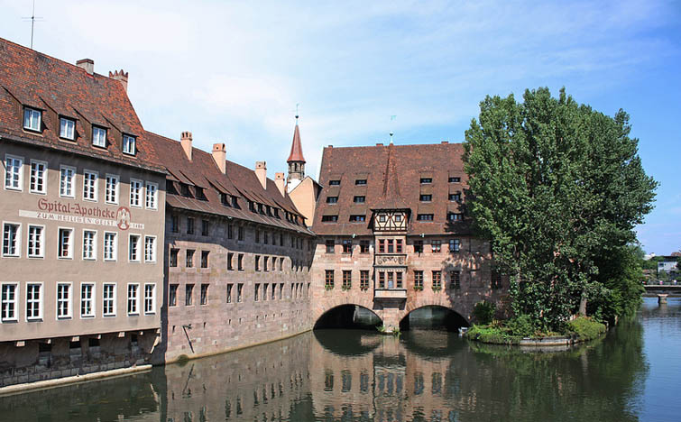
Hospital of the Holy Spirit (Heilig-Geist-Spital)
This is one of the most well-known postcards of the city of Nuremberg, photographed from the bridge opposite. On the banks of the River Pegnitz, the building was constructed between 1332 and 1339. Having fulfilled its duties as a hospital, it is currently a municipal home for the elderly.
Market Square (Hauptmarkt)
Another of the must-see spots you simply must not miss on any tour of Nuremberg, is dominated by the Church of Our Lady (Frauenkirche) built in 1358 by order of Emperor Charles IV. Its famous marketplace (particularly well-known for its Christmas Market but also offers a fresh produce and traditional food market during the rest of the year). Here you will find the Beautiful Fountain (Schöner Brunnen) that dates back to the 14th Century . The square is encircled by innumerable souvenir shops and the city tour bus stop is located right beside the historic fountain.
Bratwursthäusle
At this stage in the tour, we suggest a rest and something to fuel the stomach chance by sampling some traditional German food. Opposite the old Town Hall we found the Bratwursthäusle restaurant, where we could try the traditional German bratwurst accompanied by the equally emblematic pretzel. So sit down on the terrace and guten appetit!
Albercht Dürer’s House (Albercht Dürer Haus)
Fed and watered and after a short rest, you will be ready to walk to the highest area of the city. Before you leave the city walls, we recommend a visit to the house-museum that used to be the home of Albercht Dürer that includes in its exhibition, a chance to see the process carried out by Dürer when creating his famous etchings . Interestingly, in the square opposite the house, we discovered a curious sculpture reminiscent of one of the most well-known works by Dürer, the hare.
Imperial Castle of Nuremberg (Kaiserburg)
When you pass through the walls, you might be surprised to see gardens and orchards in the moat. The city hall rented the space out to the citizens of Nuremberg who use it as an urban vegetable patch or garden… Following the wall along for a few metres, we reach the Imperial Castle of Nuremberg from which point you can see the entire city (see the panoramic view at the start of this article). It was the residence of the German emperors from 1050 to 1571 and as well having preserved some of its original living quarters that are open to visitors, many other parts of the castle are still inhabited today.
Zeppelin Field (Zeppelinfeld)
To conclude this tour, we leave the city centre and to do this, if you haven’t done so already, we recommend you use the city’s public transport, specifically, the No. 36 bus route. You have to take this bus from the stop that is fairly near the castle then get off at the last stop on the line, that will leave you right opposite the Documentation Centre , inaugurated in 2000, the former Nazi Party Congress.
The original project for this building was to construct a half section of an amphitheatre in the style of the Roman Coliseum , with a conference auditorium in its centre. Now the building houses an interesting and modern information centre that can be visited, with a permanent exhibition documenting the history of the precinct and the ruthless abuse of power by the Nazi regime.
From there, you have to border the lake to reach the Zeppelinfeld itself: an enormous grandstand inspired by the Pergamon Altar from which Hitler directed the parades and Nazi Party congresses. Today, the area is very run-down and the city of Nuremberg only uses it for a >rock music festival held at the start of June (reminiscent of the 1970s) and a car race that takes place during the first week of July. Strange, isn’t it? Even so, you should pay a visit even if it is only to say “I’ve been there” before you go back into the city. Talking of the return, close to the Zeppelin Field there are two stops for the local train (S2) which will drop you off at Nuremberg’s central station.
Useful information
As regards transport, other than the cases we’ve mentioned, the rest of the tour can be done on foot. However, our advice is to pick up the Nürberg Cardfrom any of the city’s Tourist Offices that, for 21 €, gives you two-day access to all the museums and public transport. Children under 12 can get their card free of charge.
Another option to think about for getting around the city is NorisBike, a public bicycle hire service available to both residents of and visitors to Nuremberg. You can find more information about this service (in German) at aquí.
We’ll be there. If you want to come too, check out our flights here.
more info

The Rugged Side of Majorca
Majorca is renowned the world over for its beaches and coves, but the Sierra de Tramuntana, which rises over a thousand metres above the island’s north coast, is a veritable paradise for hiking enthusiasts. An intricate network of centuries-old tracks and footpaths has been upgraded into a set of fully-fledged walking routes traversing a surprisingly rocky landscape carpeted with dense forest. Peeping out of the clearings are a number of quaint villages and hamlets that preserve their pristine charm. A long-distance footpath, known as the Dry Stone Route (Ruta de Piedra en Seco) or GR-221, runs from one end of the range to the other, flanked by the most rugged landscapes in Majorca. The route, imbued with the region’s rich cultural heritage, covers 120 km and can be done in full or by sections. For visitors with a tight schedule, we have selected three of the best sections along the trail.
1. Ses Basses and La Trapa – the Stunning Sa Dragonera Vantage Point
The walking route starts at the Coll de Sa Gramola, a mountain pass accessible from the Andratx main road. From here, a trail heads westwards towards the caseta de Ses Basses. After that the path narrows and leads to an area with various viewpoints overlooking the sea, affording wonderful panoramic views. The trail gradually merges into the wild landscape which compounds a rugged, breathtaking setting against the backdrop of the island of Sa Dragonera protruding into the sea. After a descent flanked by vegetation, you come to an old Trappist monastery now under restoration. The project will eventually include a shelter for hikers. For the return trip, you go back the same way you came.
Recommendations:
This is an easy route, covering 15 km for the whole round trip, ideal for a morning’s hike.
Access: Coll de Sa Gramola lies 5 km from Andratx, reached via the Ma-10 main road, where there is a parking area. If you happen to come in two cars, you can extend the excursion beyond La Trapa as far as Sant Elm, where you can park one of the cars beforehand. The walking distance from Coll de Sa Gramola to Sant Elm is 13 km in all. Remember to take water as there are no drinking sources on the way and little shade.
2. Camí de s’Arxiduc – a High-Flying Lookout Between Valldemossa and Deià
The excursion begins at the Charterhouse of Valldemossa, the former residence of King Sancho I of Majorca. Exit the village of Valldemossa following the white and red markers of the GR-221 along a stony path with a steep gradient that ends at the Es Cairats shelter, which is still closed. It should be noted that original route of the GR-221 was very different from the current one as it used to go over the summit of Talaia Vella, from where it joined up with the Camí de s’Arxiduc. On the new route, old lime kilns are visible on the ascent leading to Es Cairats, as are charcoal kilns and the small shelters once inhabited by those in charge of managing resources in the magnificent holm oak woods.
After the shelter, the footpath turns into a track and you soon come to a wild, open area. The GR-221 markers lead to the summit of Puig Gros, the Pla des Aritges plain and Es Caragolí, where the route finally links up with the panoramic Camí de s’Arxiduc. Before taking a detour to descend towards Deià, it is well worth walking a few extra yards – even though this involves going back on our tracks – along this emblematic route, as it runs along the ridge of the mountains. It was commissioned by the Archduke Louis Salvador of Habsburg-Lorraine in the late-19th century for the sole purpose of being able to enjoy the scenery.
Recommendations:
While only 13 km long, the route has a difficulty of medium-high, on account of the slopes and terrain, which is very rocky and steep in some stretches.
Access: You can leave your car in Valldemossa and take the bus back from Deià.
3. From Sóller to the Monastery of Lluc – A Weekend in the Mountain Heartland
One of the most spectacular, varied, accessible and best appointed sections of the GR-221 is the one that connects the historical town of Sóller to the Monastery of Lluc. It covers a distance of 35 km and can readily be divided into two stages – of 19 km and 15 km each – with an overnight in the Tossals Verds shelter.
Stage 1 – On the first day, the GR-221 markers point you from the centre of Sóller to the bucolic Biniaraix gorge. This involves a pronounced accumulated slope, leading up to the Coll de l’Ofre and the Cúber dam. From here, the more seasoned hikers can proceed to the Tossals Verds shelter via the new Pas Llis bypass, with an added ascent and a brief, simple equipped pass. The alternative is the old route which goes around Coll des Coloms and does not entail any difficulty.
Stage 2 – After regaining your strength in the shelter, you proceed along the GR-221 towards the panoramic areas of Coll des Prat and Coll des Telègraf. From here, a long descent leads you to the monastery along a winding path which snakes through a holm-oak wood featuring old but recently restored ice pits.
Recommendations:
The trek lasts two days and the difficulty level is medium to high, as it includes steep slopes – with a daily accumulated slope of over 1,100 metres – and prolonged descents along tracks. The terrain is rocky and requires mountain footwear, in addition to trekking poles. While the path is signposted with posts, waymarkers and paint marks, it is advisable to take your own hiking map, such as the one published by the Editorial Alpina. You should also book overnights at the Tossals Verds shelter in advance, as capacity is limited (website).
Access: You can get a bus to Sóller from Palma, or you can travel on the old Sóller railway, which has been plying the route daily since 1912. You can take the L330 line bus to make the return journey from Lluc to Palma.
Don’t wait to discover the rugged enclaves of Majorca – check out our flights here.
Text by Sergio Fernández Tolosa & Amelia Herrero Becker of Con Un Par de Ruedas
Photos by Con Un Par de Ruedas
more info
Julio Cortázar and Rayuela's Paris
Even the experts consider it an ‘antinovel’, there is no doubt that Rayuela influenced many generations since it was released and, because of it, Julio Cortázar became a literary benchmark whose centenary of his birth is celebrated this year. If Maga and this unparalleled adventure in Paris also fascinated you, our route through the French capital will help you remembering the most remarkable moments in Horacio Oliveira’s history.
"¿Will I find Maga? Many times I just had to look out coming by rue de Seine, the arch that takes you to Quai de Conti, and only the olive and ash light floating on the river let me distinguish the forms, its tiny shape by Pont des Arts, sometimes walking from side to side, sometimes stopped at the iron parapet, leaned against the water. And it was so natural to cross the street, ascend the steps on the bridge, get in the tiny waist and get closer to Maga smiling unsurprisingly, convinced like me that a chance encounter was the less casual in our life, and that people who arrange dates is the same that needs ruled paper to write each other or that pushes from the bottom the tooth paste”
Quai de Conti: The novel, like our route, starts at rue de Seine, Quai de Conti and Pont des Arts, places where Horacio y Maga met each other, with a special symbolism for the author considering the centric location of this part of the route that take us along the left side of Seine river. Our protagonist also mentions the library Mazarine, located at the other side of the arch and the most antique library in the country.
Pont des Arts: As a connection between Institut de France and Louvre (previously known as Arts Palace), you can find the centric iron bridge where Oliveira got drunk at the first part of the book. Now full of lockers promising everlasting love, the panoramic views over Cité island and all the bridges is one of the most beautiful pictures you can take of the city.
Louvre Museum: Even Rayuela is full of cultural references, when we are talking about visual arts Louvre museum is the only reference Cortázar gives us about this city on this field. The most visited arts museum in the world appears on our way after taking Pont des Arts. This place is a must to anyone because of its wide collection and masterpieces such as “La Gioconda” by Leonardo da Vinci and a stunning building including, since the 80s, a great glass pyramid that you should visit.
Rue du Jour: The latest partners of Horacio at the city, homeless people, feed themselves thanks to the soup dish that they receive here. By the church Saint Eustache, people in need receives food at this street, located at Les Halles, a gardened area right in the city centre where there are two more places we will pass by.
"Au chien qui fume" restaurant: Located at Rue du Pont Neuf, this is one of the cafés named at chapter 132 and is also a meeting point for Etienne and Horacio on the way to the hospital to visit Morelli. This is a typical French restaurant, with an elegant and traditional decoration and a careful cuisine selection. Following this street we find the next stop…
Pont Neuf: Even it name means new bridge, it’s completely the opposite, and it’s the oldest. Here we say goodbye to Horacio and Maga in this route. Made of arches, the bridge took almost 30 years on the making and during the 18th century it was the centre of crime and commerce in the city. Passing by the bridge we will go back to the left side of the Seine, where we will stay.
Rue Dauphine: Even it’s part of a dispensable chapter, Pola, Horacio’s French lover, lives in this street. The street starts after Pont Neuf, and it was named after France’s dauphine, Henri IV’s son.
Rue de la Huchette: This is another place where Horacio thinks his lover can be at. A must-visit pedestrian street with many famous places like the theatre Huchette and Caveau de la Huchette. We pass through from the boulevard Saint-Michel until we reach Rue du Petit-Pont, before we get to the Notre-Dame cathedral.
Notre Dame: Chance makes the protagonists meet again at this iconic landmark of the city, one of the most beautiful and most visited French gothic cathedrals, which was finished on 1345 and is located at the Cité island. Who hasn’t heard about Notre Dame and its famous hunchback? Either as the Quasimodo by Victor Hugo or by Disney, the gargoyles are part of the collective imaginary
Rue du Sommerard: The street where Horacio Oliveira lives and one of the oldest in the city, which during the Roman age took to the baths at Cluny. Next to the famous Saint-Germain Boulevard, Sommerand is nonetheless more relaxed and perfect to take a relaxed walk.
Rue Valette: This is a magic place for our protagonists, in one of the hotels here they consummate the relationship for the first time and here is also where Horacio took Pola. Rue Valette is at the quarter of Sorbonne University and follows the Rue de Carmes, the meeting point for students.
Rue Monge: One of the places where is believed Maga lived after separation and the death of his son Rocamadour. This is a important street located at the university area on the Paris district nº 5.
Rue Monsieur Le Prince: The incomprehensible chance also takes place at this street, which used to be a road and leads to the Edmond Rostand Square along the Saint-Michel Boulevard. Notice also that Polidor restaurant, where the story of Cortazar’s "62 A Model Kit" takes place, is also here. We pass by this place if we go to Odeon.
Rue l’Odéon: Remember here, with Horacio, parts of his relation with Maga, eating at Carrefour de l’Odeon and riding the bike by Montparnasse. The impressive Odeon theatre gives the name to this street and neighbourhood, full of life by night and day, where we can find all kinds of bars, cafés and restaurants. From here, take Saint-Sulpice Street to arrive to the next stop.
Rue de Tournon: This is the street where we walk back to Madame Trépat house, with Horacio. Even traditionally it was full of old bookstores, many luxury fashion shops moved here on the past few years. It’s one of the most prestigious streets, from the Senate and across Saint-Sulpice street, which lead us to the end of this route. Mario Vargas Llosa lived here too.
Montparnasse cemetery: The last stop in this route is also the location at the last chapter of Rayuela, where Horacio takes a little paper and also where Julio Cortázar was buried. At the hearth of Montparnasse neighbourhood, this was inaugurated on 1824 and is the second in the city, with many remarkable people resting here along with the author, such as Simone de Beauvoir, Samuel Beckett or Jean Paul Sartre.
Image from Henri Marion
A place well worth discovering! Check out our flights here.
more info
Magical Routes
The scenery in this land is highly varied, featuring the best of Cantabria, with its rugged coastline and inland landscapes blessed with nature in its pristine state. We are going to concentrate on two routes that traverse the province and boast an extraordinary historical and cultural legacy, studded with a host of priceless Romanesque churches. Both are listed as World Heritage by UNESCO.
The Northern Road to Santiago
Also known as the “Coastal Road” and running for 936 kilometres, in the Middle Ages it acted as a distribution network along the north of the Iberian Peninsula. The coastal road coincides roughly with the current layout of main roads, stretching across the whole region from east to west.
The miraculous discovery in 813 of the tomb of St James sparked the beginning of the pilgrimages to Santiago de Compostela, situated at the western edge of the known world. This centre of pilgrimage gradually grew in importance, vying with others in Rome, Jerusalem and Liébana. The pilgrims took the roads that led westwards which were generally old Roman ways still in use. In addition to the main route, which led across the north of the Meseta, there were alternative routes like the coastal road, part of which ran through Cantabria’s maritime districts. Thus, the road led through Castro Urdiales, Comillas, Laredo, Santander, Santillana del Mar and San Vicente de la Barquera, all of which boast valuable medieval religious buildings, both Romanesque and Gothic.
You are advised to negotiate the route in nine stages:
Stage 1. El Haya de Ontón – Castro Urdiales (21 km)
This is the first stage on the Northern Road through Cantabria. It leads through Baltezana, Otañes, Santullán and Sámano. The route is smooth, with no marked slopes, and has restaurant facilities, rest areas and drinking fountains.
Stage 2. Castro Urdiales – Guriezo (12.9 km)
A short stage. It is worth taking time to visit the Gothic church of Santa María, particularly its interior. You will pass through the villages of Allendelagua, Cérdigo, Islares and Nocina. The standout stretch is the last three kilometres, with stunning views of the Cantabrian Sea.
Stage 3. Guriezo – Laredo (23.1 km)
This takes you through Rioseco, Tresagua, Lugarejos, Iseca Nueva, Sopeña and, on the way to Laredo, through Iseca Vieja, Las Cárcobas and Valverde. The most prominent features include the hillside walk which culminates in your first glimpses of the Liendo Valley, the beautiful scenery around San Julián beach, and the town of Laredo, with memories of its medieval and modern history cast in stone.
Stage 4. Laredo – Güemes (36 km)
The municipalities traversed on this stage are Santoña, Argoños, Helgueras, Noja, Soano, Isla, Bareyo and Güemes. Noteworthy in Laredo is its 16th-century Town Hall. This is followed by a stroll along the beaches of Salvé, which stretches for over 4 kilometres, and Berria. When you come to Bareyo, make sure you visit its church, a gem of the Cantabrian Romanesque.
Stage 5. Güemes – Santander (18 km)
A short stage which allows you to explore the capital of Cantabria more fully. The places you pass through are Galizano, Somo, Pedreña and Santander. In the capital, the acclaimed landmarks include the historic centre and the Reina Victoria promenade. Don’t miss out on the Jardines de Pereda and the Cathedral, set behind the post office, in addition to the Iglesia del Cristo, where you can get your pilgrim credentials, both for the Road to Santiago and the Lebaniego Road.
Stage 6. Santander – Santillana del Mar (40 km)
Peñacastillo, Santa Cruz de Bezana, Puente Arce, Requejada, Barreda and Queveda are the population centres you traverse on this stage. From a cultural standpoint, the most striking landmarks are the 16th-century Arce bridge and the town of Santillana del Mar, a medieval museum in itself.
Stage 7. Santillana del Mar – Comillas (24.6 km)
This is a beautiful stage which, like the previous one, can be broken into two parts. One as far as Cóbreces and the other up to Comillas. Both are worthy of stopovers as they boast historical complexes. And, make sure you don’t miss the villa of the Marqueses de Comillas with its Catalan Modernist features.
Stage 8. Comillas – San Vicente de la Barquera (12.5 km)
The highlights of this stage are undoubtedly the above two towns, and the scenery along the Cantabrian seaboard which connects them. The route takes you through Rubárcena, La Rabia, Guerra, Rupuente and La Braña. Keep your camera or mobile handy as you’ll be passing through the Oyambre Nature Reserve and some idyllic beaches.
Stage 9. San Vicente de la Barquera – Unquera (16.4 km)
Everywhere you look around you reveals stunning scenery. Behind you lies the town of San Vicente and, to the front, the spectacular Picos de Europa mountain range. This stage takes you through La Acebosa, Hortigal, Estrada, Serdio and Pesués. While you’re at it, between San Vicente de la Barquera and Unquera you can take a detour at Muñorrodero if you also want to do the Lebaniego Road.
The Lebaniego Road
This is one of the most important and beautiful pilgrim routes. In fact, 2017 will be a Jubilee Year in Liébana. The Lebaniego Road runs from San Vicente de la Barquera to the Monastery of Santo Toribio, passing through the municipalities of Val de San Vicente, Herrerías, Lamasón, Peñarrubia, Cillorigo, Potes and Camaleño. The route traverses some beautiful natural spots and boasts fine examples of Cantabria’s architectural heritage. It also provides access to the Northern Road (or Coastal Road), the French Road and the Road to Santiago from the routes in León and Palencia, pointing to the historic ties between the diocese of Liébana and the kingdoms of León and Castile. Many pilgrims make the journey to Santo Toribio and then connect up with the two roads to Santiago for the purpose of attaining both credentials. It is advisable to negotiate this route in three stages:
1st Stage. San Vicente – Cades (28 km):
San Vicente de la Barquera is one of the major and most touristic towns in Cantabria. Although outside the scope of the pilgrim’s route, it also features interesting sites like the 13th-century Castillo del Rey, the 15th-century Convent of San Luis, where Charles V lodged before being proclaimed king in 1517, the bridge known as Puente de la Maza and the Sanctuary of La Barquera, both dating from the 15th century. From there you set out to Serdio, and on to the mountain trail that leads to Muñorrodero. The trail ends in Camijanes. You then pass through Cabanzón with its Medieval Tower and, finally, you come to Cades.
2nd Stage. Cades – Cabañes (30.53 km):
From Cades, you head for La Fuente. There you can visit the Church of Santa Juliana, one of the jewels of Romanesque art in Cantabria, listed as a Cultural Interest Site. After reaching Cicera, the road leads to Lebeña, passing through an oak and beech forest with millennial specimens, as well as field mushrooms of all kinds in season. The route ends in Cabañes after negotiating a slope.
3rd Stage. Cabañes – Santo Toribio (13.7 km):
The first stop is in Pendes, which you cannot leave without trying Liébana’s typicalquesucocheese. From there, the road leads to Tama, and then on to Potes, with its impressive Torre del Infantado, the town’s most emblematic landmark and one of the finest in Cantabria. It makes a priceless picture with the Picos de Europa in the background. Finally, you come to the Monastery of Santo Toribio, where the Lignun Crucis is venerated. The classical Gothic and Baroque monastery was built from the 13th to the 18th century. It features the 15th-century Gate of Pardon which is opened every Lebaniego Jubilee Year; that is, every time 16 April falls on a Sunday, the feast of the monk St Toribio, a historic figure acclaimed for having brought the Lignum Crucis to Liébana. This is regarded as the largest relic of Christ’s Cross.
Full information on the Road can be found here. In addition to the information, news and routes, there is a link to a map of the Road.
Millennary Yet Modern Road
The Lebaniego Road was the first pilgrim’s route to have a wi-fi internet connection, thanks to the project, Camino Lebaniego en Red. The connection is achieved via a system of waymarkers that provide a signal throughout the route. The technology enables travellers to interact with one another, access information and share their experience with other pilgrims. It is also accessible to people with disabilities and is generally designed as a comprehensive system for those covering the 72 kilometres of road. More information here.
So, take up your backpack and don your sturdy footwear for the journey. Live out the experience of the Road for yourself. Check out our flights here.
Text and images by Turismo de Cantabria
more info